Pictures
| # |
ID


|
Uploaded by
|
Uploaded on

|
Picture
|
Description
|
Related item(s)
|


|
| 5701 |
6483 |
 bali |
2018-05-25 21:22:34 |
 |
By United States Geological Survey (USGS) - USGS via TopoQuesthttp://www.topoquest.com/map.php?lat=28.72751&lon=-96.25096&datum=nad83&zoom=4&map=sat1m&coord=d&mode=zoomin&size=l, Public Domain, https://commons.wikimedia.org/w/index.php?curid=1954985 |
Airport Palacios Municipal Airport (KPSX) |
|
| 5702 |
6482 |
bali |
2018-05-25 21:22:21 |
 |
By User:Ruhrfisch - took it myself, CC BY-SA 3.0, https://commons.wikimedia.org/w/index.php?curid=7722042 |
Airport Mid-State Regional Airport (KPSB) |
|
| 5703 |
6481 |
bali |
2018-05-25 21:22:12 |
 |
By United States Geological Survey (USGS) - USGS via TopoQuesthttp://www.topoquest.com/map.php?lat=33.63667&lon=-95.45083&datum=nad83&zoom=4&map=sat1m&coord=d&mode=zoomin&size=l, Public Domain, https://commons.wikimedia.org/w/index.php?curid=1954770 |
Airport Cox Field (KPRX) |
|
| 5704 |
6480 |
bali |
2018-05-25 21:22:00 |
 |
By United States Department of Agriculture (USDA), Farm Services Agency - National Agriculture Imagery Program (NAIP) Orthoimagery for Zone 16 Alabama State Quarter Quadrangle MERIDIANVILLE, NW and I.D. # n_3408612_nw_16_1_20060629.tif, Public Domai |
Airport Mac Crenshaw Memorial Airport (KPRN) |
|
| 5705 |
6479 |
bali |
2018-05-25 21:21:46 |
 |
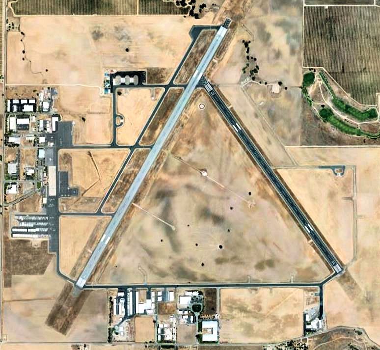
By C.Lambert - I created this work entirely by myself., CC BY 3.0, https://en.wikipedia.org/w/index.php?curid=22488343 |
Airport Paso Robles Municipal Airport (KPRB) |
|
| 5706 |
6478 |
bali |
2018-05-25 21:21:38 |
 |
By United States Geological Survey (USGS) - USGS orthophoto via MSR Maps (formerly TerraServer-USA), Public Domain, https://commons.wikimedia.org/w/index.php?curid=3727906 |
Airport Northern Maine Regional Airport at Presque Isle (KPQI) |
|
| 5707 |
6477 |
bali |
2018-05-25 21:21:26 |
 |
By InSapphoWeTrust from Los Angeles, California, USA - Los Angeles County Fairgrounds from United 41, CC BY-SA 2.0, https://commons.wikimedia.org/w/index.php?curid=24266826 |
Airport Brackett Field (KPOC) |
|
| 5708 |
6476 |
bali |
2018-05-25 21:21:16 |
 |
By United States Geological Survey (USGS) - USGS digital orthophoto via MSR Maps (formerly TerraServer-USA), Public Domain, https://commons.wikimedia.org/w/index.php?curid=8070705 |
Airport Princeton Municipal Airport (Minnesota) (KPNM) |
|
| 5709 |
6475 |
bali |
2018-05-25 21:21:05 |
 |
By Ken Lund from Reno, Nevada, USA - Northeast Philadelphia Airport, Pennsylvania, CC BY-SA 2.0, https://commons.wikimedia.org/w/index.php?curid=45408409 |
Airport Northeast Philadelphia Airport (KPNE) |
|
| 5710 |
6474 |
bali |
2018-05-25 21:20:55 |
 |
By United States Geological Survey (USGS) - USGS via TopoQuesthttp://www.topoquest.com/map.php?lat=36.73194&lon=-97.09972&datum=nad83&zoom=4&map=sat1m&coord=d&mode=zoomin&size=l, Public Domain, https://commons.wikimedia.org/w/index.php?curid=1957348 |
Airport Ponca City Regional Airport (KPNC) |
|
| 5711 |
6473 |
bali |
2018-05-25 21:20:41 |
 |
CC BY-SA 3.0, https://en.wikipedia.org/w/index.php?curid=9372004 |
Airport Greater Portsmouth Regional Airport (KPMH) |
|
| 5712 |
6472 |
bali |
2018-05-25 21:20:34 |
 |
By United States Geological Survey (USGS) - USGS via TopoQuesthttp://www.topoquest.com/map.php?lat=34.62561&lon=-118.08954&datum=nad83&zoom=8&map=sat1m&coord=d&mode=zoomout&size=l, Public Domain, https://commons.wikimedia.org/w/index.php?curid=19871 |
Airport Palmdale Regional Airport (KPMD) |
|
| 5713 |
6471 |
bali |
2018-05-25 21:20:21 |
 |
By United States Department of Agriculture (USDA), Farm Services Agency - National Agriculture Imagery Program (NAIP) Orthoimagery for Zone 16 Alabama State Quarter Quadrangle ANDALUSIA, NE and I.D. # n_3108645_ne_16_1_20060622.tif, Public Domain, h |
Airport St. Clair County Airport (KPLR) |
|
| 5714 |
6470 |
bali |
2018-05-25 21:20:08 |
 |
By Royalbroil - Own work, CC BY-SA 3.0, https://commons.wikimedia.org/w/index.php?curid=17982748 |
Airport Pellston Regional Airport (KPLN) |
|
| 5715 |
6469 |
bali |
2018-05-25 21:19:59 |
 |
By KTrimble (talk) (Uploads) - Own work, Public Domain, https://commons.wikimedia.org/w/index.php?curid=61576671 |
Airport M. Graham Clark Downtown Airport (KPLK) |
|
| 5716 |
6468 |
bali |
2018-05-25 21:19:50 |
 |
By Frankfurtcessna - Own work, CC BY-SA 4.0, https://commons.wikimedia.org/w/index.php?curid=49151262 |
Airport Zelienople Municipal Airport (KPJC) |
|
| 5717 |
6467 |
bali |
2018-05-25 21:19:41 |
 |
By United States Geological Survey (USGS) - USGS via TopoQuesthttp://www.topoquest.com/map.php?lat=44.38120&lon=-100.28524&datum=nad83&zoom=4&map=sat1m&coord=d&mode=pan&size=l, Public Domain, https://commons.wikimedia.org/w/index.php?curid=19555275 |
Airport Pierre Regional Airport (KPIR) |
|
| 5718 |
6466 |
bali |
2018-05-25 21:19:29 |
 |
By United States Geological Survey (USGS) - USGS via TopoQuesthttp://www.topoquest.com/map.php?lat=42.91038&lon=-112.58633&datum=nad83&zoom=8&map=sat1m&coord=d&mode=zoomout&size=l, Public Domain, https://commons.wikimedia.org/w/index.php?curid=19556 |
Airport Pocatello Regional Airport (KPIH) |
|
| 5719 |
6465 |
bali |
2018-05-25 21:19:16 |
 |
By United States Geological Survey (USGS) - USGS The National Map, via MSR Maps (formerly TerraServer-USA)Image: http://msrmaps.com/GetImageArea.ashx?t=1&s=10&lat=31.4671&lon=-89.3351&w=1400&h=2000Interactive map: http://msrmaps.com/map.aspx?t=1&s=1 |
Airport Hattiesburg-Laurel Regional Airport (KPIB) |
|
| 5720 |
6464 |
bali |
2018-05-25 21:19:02 |
 |
By Mytwocents at English Wikipedia, CC BY-SA 3.0, https://commons.wikimedia.org/w/index.php?curid=13562215 |
Airport Newport News/Williamsburg International Airport (KPHF) |
|
| 5721 |
6463 |
bali |
2018-05-25 21:18:54 |
 |
By Eric Salard - PGA PAGE MUNICIPAL AIRPORT FROM FLIGHT LAX-CDG 777 F-GSPY, CC BY-SA 2.0, https://commons.wikimedia.org/w/index.php?curid=29389046 |
Airport Page Municipal Airport (KPGA) |
|
| 5722 |
6462 |
bali |
2018-05-25 21:18:43 |
 |
By United States Geological Survey (USGS) - USGS via GPS Visualizer websitehttp://www.gpsvisualizer.com/map_input?special=wikipedia&format=google&bg_map=usgs_aerial&sp_width=50km&form:data=type,name,latitude,longitude%0DW,%22Pecos%20Municipal%20Airp |
Airport Pecos Municipal Airport (KPEQ) |
|
| 5723 |
6461 |
bali |
2018-05-25 21:18:30 |
 |
By Visitor7 - Own work, CC BY-SA 3.0, https://commons.wikimedia.org/w/index.php?curid=16978734 |
Airport Eastern Oregon Regional Airport (KPDT) |
|
| 5724 |
6460 |
bali |
2018-05-25 21:18:22 |
 |
CC BY 2.5, https://en.wikipedia.org/w/index.php?curid=12768867 |
Airport DeKalb-Peachtree Airport (KPDK) |
|
| 5725 |
6459 |
bali |
2018-05-25 21:18:13 |
 |
By Royalbroil - Own work, CC BY-SA 3.0, https://commons.wikimedia.org/w/index.php?curid=8255477 |
Airport Prairie du Chien Municipal Airport (KPDC) |
|
|
|
|
|
|
|
|
|
| # |
ID
|
Uploaded by
|
Uploaded on
|
Picture
|
Description
|
Related item(s)
|
|