Pictures
| # |
ID


|
Uploaded by
|
Uploaded on

|
Picture
|
Description
|
Related item(s)
|


|
| 5901 |
6282 |
 bali |
2018-05-25 20:46:42 |
 |
By United States Geological Survey (USGS) - USGS The National Map, via MSR Maps (formerly TerraServer-USA)http://msrmaps.com, Public Domain, https://commons.wikimedia.org/w/index.php?curid=3722049 |
Airport San Marcos Municipal Airport (KHYI) |
|
| 5902 |
6281 |
bali |
2018-05-25 20:46:31 |
 |
By Famartin - Own work, CC BY-SA 4.0, https://commons.wikimedia.org/w/index.php?curid=54622300 |
Airport Warrenton-Fauquier Airport (KHWY) |
|
| 5903 |
6280 |
bali |
2018-05-25 20:46:22 |
 |
By U. S. Fish and Wildlife Service - Northeast Region - https://www.flickr.com/photos/usfwsnortheast/8154109757/, Public Domain, https://commons.wikimedia.org/w/index.php?curid=51931352 |
Airport Brookhaven Airport (KHWV) |
|
| 5904 |
6279 |
bali |
2018-05-25 20:46:12 |
 |
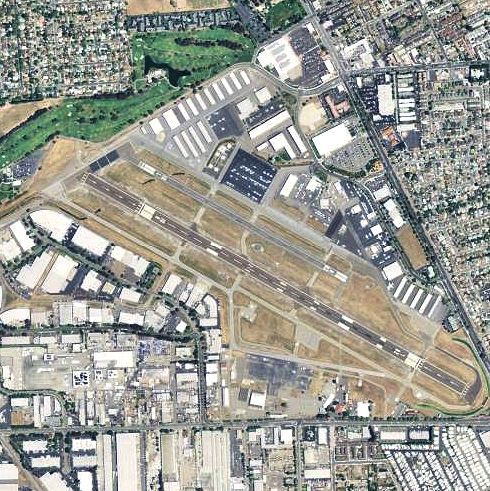
By United States Geological Survey - USGS via TopoQuest, Public Domain, https://commons.wikimedia.org/w/index.php?curid=19861581 |
Airport Hayward Executive Airport (KHWD) |
|
| 5905 |
6278 |
bali |
2018-05-25 20:46:02 |
 |
By United States Department of Agriculture (USDA), Farm Services Agency - National Agriculture Imagery Program (NAIP) Orthoimagery for Zone 16 Alabama State Quarter Quadrangle MADISON, NE and I.D. # n_3408619_ne_16_1_20060629.tif, Public Domain, htt |
Airport Redstone Army Airfield (KHUA) |
|
| 5906 |
6277 |
bali |
2018-05-25 20:45:49 |
 |
By United States Geological Survey (USGS) - USGS The National Map, via MSR Maps: Image, Interactive map, Public Domain, https://commons.wikimedia.org/w/index.php?curid=17099542 |
Airport Tri-State Airport (KHTS) |
|
| 5907 |
6276 |
bali |
2018-05-25 20:45:38 |
 |
CC BY-SA 2.5, https://en.wikipedia.org/w/index.php?curid=7248972 |
Airport East Hampton Airport (KHTO) |
|
| 5908 |
6275 |
bali |
2018-05-25 20:45:31 |
 |
By United States Department of Agriculture (USDA), Farm Services Agency - National Agriculture Imagery Program (NAIP) Orthoimagery for Zone 16 Alabama State Quarter Quadrangle MASON RIDGE, NW and I.D. # n_3408626_nw_16_1_20060629.tif, Public Domain, |
Airport Huntsville International Airport (KHSV) |
|
| 5909 |
6274 |
bali |
2018-05-25 20:45:17 |
 |
By Devastator (talk) - I created this work entirely by myself., Public Domain, https://en.wikipedia.org/w/index.php?curid=22868062 |
Airport Billy Mitchell Airport (KHSE) |
|
| 5910 |
6273 |
bali |
2018-05-25 20:45:08 |
 |
By United States Geological Survey (USGS) - USGS via TopoQuesthttp://www.topoquest.com/map.php?lat=30.36778&lon=-89.45472&datum=nad83&zoom=4&map=sat1m&coord=d&mode=zoomin&size=l, Public Domain, https://commons.wikimedia.org/w/index.php?curid=2007597 |
Airport Stennis International Airport (KHSA) |
|
| 5911 |
6272 |
bali |
2018-05-25 20:44:55 |
 |
By United States Geological Survey (USGS) - USGS via GPS Visualizer websitehttp://www.gpsvisualizer.com/map_input?special=wikipedia&format=google&bg_map=usgs_aerial&sp_width=50km&form:data=type,name,latitude,longitude%0DW,%22Herington%20Regional%20A |
Airport Herington Regional Airport (KHRU) |
|
| 5912 |
6271 |
bali |
2018-05-25 20:44:42 |
 |
By KTrimble at English Wikipedia, CC BY-SA 3.0, https://commons.wikimedia.org/w/index.php?curid=61576567 |
Airport Boone County Airport (Arkansas) (KHRO) |
|
| 5913 |
6270 |
bali |
2018-05-25 20:44:34 |
 |
By Tedder - Own work, CC BY 3.0, https://commons.wikimedia.org/w/index.php?curid=6850078 |
Airport Hermiston Municipal Airport (KHRI) |
|
| 5914 |
6269 |
bali |
2018-05-25 20:44:25 |
 |
By Sam Beebe/Ecotrust, CC BY-SA 3.0, https://commons.wikimedia.org/w/index.php?curid=47831644 |
Airport Bowerman Airport (KHQM) |
|
| 5915 |
6268 |
bali |
2018-05-25 20:44:17 |
 |
By United States Geological Survey (USGS) - USGS via TopoQuesthttp://www.topoquest.com/map.php?lat=32.68750&lon=-103.21694&datum=nad83&zoom=4&map=sat1m&coord=d&mode=zoomin&size=l, Public Domain, https://commons.wikimedia.org/w/index.php?curid=195458 |
Airport Lea County Regional Airport (KHOB) |
|
| 5916 |
6267 |
bali |
2018-05-25 20:44:04 |
 |
By Alan Wilson from Stilton, Peterborough, Cambs, UK - Cessna Citationjet CJ3+ |
Airport Henderson Executive Airport (KHND) |
|
| 5917 |
6266 |
bali |
2018-05-25 20:43:54 |
 |
By United States Geological Survey (USGS) - USGS via TopoQuesthttp://www.topoquest.com/map.php?lat=33.73284&lon=-117.02207&datum=nad83&zoom=2&map=sat1m&coord=d&mode=zoomin&size=l, Public Domain, https://commons.wikimedia.org/w/index.php?curid=199437 |
Airport Hemet-Ryan Airport (KHMT) |
|
| 5918 |
6265 |
bali |
2018-05-25 20:43:41 |
 |
By United States Air Force - United States Air Force, Public Domain, https://commons.wikimedia.org/w/index.php?curid=52749468 |
Airport Holloman AFB (KHMN) |
|
| 5919 |
6264 |
bali |
2018-05-25 20:43:32 |
 |
By United States Geological Survey (USGS) - USGS via TopoQuesthttp://www.topoquest.com/map.php?lat=46.60718&lon=-111.98072&datum=nad83&zoom=4&map=sat1m&coord=d&mode=zoomin&size=l, Public Domain, https://commons.wikimedia.org/w/index.php?curid=195259 |
Airport Helena Regional Airport (KHLN) |
|
| 5920 |
6263 |
bali |
2018-05-25 20:43:19 |
 |
By Bradley Bormuth - Own work, CC BY-SA 3.0 us, https://commons.wikimedia.org/w/index.php?curid=9441941 |
Airport Hickory Regional Airport (KHKY) |
|
| 5921 |
6262 |
bali |
2018-05-25 20:43:11 |
 |
By United States Geological Survey (USGS) - USGS The National Map, via MSR Maps (formerly TerraServer-USA), Public Domain, https://commons.wikimedia.org/w/index.php?curid=6597050 |
Airport Hawkins Field (airport) (KHKS) |
|
| 5922 |
6261 |
bali |
2018-05-25 20:43:00 |
 |
By Civil Air Patrol - Arkansas Department of Aeronautics, Public Domain, https://commons.wikimedia.org/w/index.php?curid=31083200 |
Airport Blytheville Municipal Airport (KHKA) |
|
| 5923 |
6260 |
bali |
2018-05-25 20:42:50 |
 |
By United States Geological Survey (USGS) - USGS The National Map, via MSR Maps (formerly TerraServer-USA)http://msrmaps.com/map.aspx?t=1&s=12&lon=-118.335278&lat=33.922778&w=600&h=400, Public Domain, https://commons.wikimedia.org/w/index.php?curid= |
Airport Hawthorne Municipal Airport (California) (KHHR) |
|
| 5924 |
6259 |
bali |
2018-05-25 20:42:37 |
 |
By Jonmkj - Own work, Public Domain, https://commons.wikimedia.org/w/index.php?curid=6322402 |
Airport Camp Mackall (KHFF) |
|
| 5925 |
6258 |
bali |
2018-05-25 20:42:29 |
 |
By United States Geological Survey (USGS) - USGS The National Map, via MSR Maps (formerly TerraServer-USA), Public Domain, https://commons.wikimedia.org/w/index.php?curid=3923963 |
Airport Hartford-Brainard Airport (KHFD) |
|
|
|
|
|
|
|
|
|
| # |
ID
|
Uploaded by
|
Uploaded on
|
Picture
|
Description
|
Related item(s)
|
|